SUMMIT
Technology Group


  Home | Products & Services | Customer Service & Support X


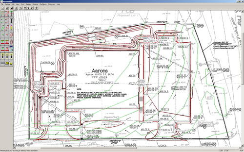
EarthWorks - Excavation & Grading Software      


EarthWorks is the easiest-to-use, most affordable, full featured cut & fill software available for Excavation, Grading, Paving & General Contractors, Homebuilders
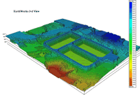
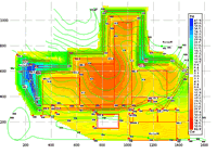
 and Developers.

With EarthWorks, you don't have to be a grading expert to quickly and accurately generate cut/fill, base, paving and other material quantities from drawings. Using an SLVI Digitizer or Roll-up III Digitizer or the optional OnScreen module, simply trace existing and proposed/new contours, areas of over-excavation, perimeters of paving areas and building pads and let EarthWorks run the calculations in seconds.

EarthWorks generates cut & fill and import/export quantity reports with topsoil and over-excavation volumes, 3D site views of existing and proposed/new elevations, cut & fill plan grids with depths and quantities, and cross sections at any location.

Need to calculate site trench material quantities?, EarthWorks also has trench take-off capabilities. Simply trace the pipe or conduit runs from your plan and input trench variables into the dynamic cross section window. Trench material quantities and cross section views are automatically generated and updated as changes are made.

EarthWorks Screen Views

EarthWorks Interface
3D Site View
Site Cross-Section View
Color Cut & Fill Grid View
Measurements View (Area, Length, Count)

Program Features

Data Input Items

Existing continuous, point to point and spot elevations/contours
Proposed/New continuous, point to point and spot elevations/contours
Point-to-Point contour copy/offset by distance and grade for hillside steps and retaining walls
Detail/Section Assemblies for paving and slabs
Paving and building pad areas
Subgrade/Base areas
Over-Excavation areas
Areas where topsoil is to be stripped and stripped/respread
Work areas for quantity subtotaling
Utility trenches with bedding and backfill
Soil report boring locations and depth/material data
Compression/Expansion factors
Areas to be demolished such as asphalt paving or concrete slabs
Curb & Gutter and other length items to be measured

Editing and Option Items

English, metric and auto scales Undo/Backspace Points Define multiple work areas
Voice elevation feedback Elevation editing User specified embankment slopes
Min/Max elevation error detection Drawing rescale Shift elevations
Manual/Auto site balancing Add text to drawings Timed backup

Reports & Graphs

3D site view Cut & Fill Import/Export quantities Topsoil & Overexcavation
Cut & Fill grid plans Trench material quantities Cross sections with strata
Measurement totals Rough staking Existing & Proposed grids

EarthWorks Add-on Modules

EarthWorks Digitizer Module - EarthWorks interface for digitizer input

EarthWorks Pro Add-on Module - Import standard CAD DXF and DWG drawing files

EarthWorks OnScreen Add-on Module - Import plan PDF and TIFF drawing files for use as backgrounds for OnScreen/Mouse Take-off

Support Plans - EarthWorks Version 3.15a Currently Shipping

Annual support plans are offered with a combination of options including;
EarthWorks support website access for self-service support, software updates, phone & e-mail support

System Requirements

Computer with Windows Operating System NT/2000/XP/Vista/Windows 7, minimum 1G of RAM and 1 dedicated USB port. For digitizer input; a tablet based digitizer SLVI Digitizer or Roll-up III Digitizer is required in addition to a 2nd dedicated USB port and wintab compatible driver.

All brand or product names are trademarks or registered trademarks of their respective companies or organizations.


Questions? Need More Information?
Call 800-792-8059 or send an email
Product Literature & Pricing
Demo Software Downloads
Online Demonstrations
On-Site Demonstrations
Software Upgrades & Maintenance


OnScreen Input with background PDF


3D Site View


Color Cut & Fill Grid View


| © 1994-2011 stg | Contact | Los Angeles | Denver